
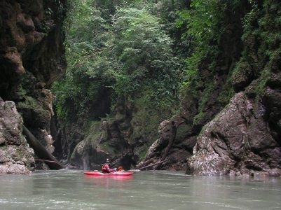
Class: V- ; Ave. Gradient: 14 m/km; Portages: maybe 1; Length: 22-28 km; Time: 7-8 hours
Season: July to January; rafts? no; Highlights: deep narrow canyon; Crux Move: Slickrock drop (V-)
Water Quality: good; Water Temperature: cold
PI: Guadalupe Paxilhá (elev.: 560m); TO: highway bridge
Description: (click here for general notes about my descriptions)
The upper Agua Azul is an all-but-unknown creeking gem with one of the more spectacular canyons you will ever pass through. It is so narrow that it is positively cave-like; in fact, you do pass through a short tunnel at one point. The long canyon is tiring and committing, however, and offers the threat of nasty strainers requiring creative portaging.
The first hour-plus to San Sebastián Paxilhá (6.5km) is wide and shallow class II with some of the best river birding I've seen. San Sebastián has car access so it is an alternate PI for those wanting a shorter run (or when the water is low). About 30 minutes later you enter a rockier section with pretty class II/III mini-gorges with pretty side spring waterfalls. This section lasts about half an hour. In the next hour and a half the difficulty is stepped up a notch, with intermittent technical class IV (with a class V or two at higher flows) through some impressive boulder gardens.
At this point the walls close in on you and you're committed. For the next 3 hours or so you're in a deep narrow spooky trench. The rapids in here are not overly long or convoluted however, mostly class III ledge drops. There is an X factor though which will cause you to scout often: wood. Large logs get trapped easily in here, and can turn a straightforward drop into a death trap. And the canyon is not always friendly with the scouting and portaging options, so be careful and prepared.
There is one rapid in the canyon that will give you pause for sure, even without any wood. I call it Slickrock and label it a flow-dependent V, and it's about an hour into this narrow section. It's a pushy triple-drop with a dangerous undercut eddy "cave" at the bottom that is not easy to avoid. While a portage route exists, it is over rock that is so slick with algae that it is almost impassable without using a rope. One nice feature of the rapid is that you are treated to some photogenic views downstream while scouting/portaging.
At the end of this spectacular section the canyon gets so narrow that the sides actually touch and you are in a cave for 10 seconds or so (yes you can see the exit from the entrance). In 2011 the cave entrance was blocked by a huge stump that had to be portaged and seal-launched-off. Just below there is tight constriction (that was runnable), and then the canyon opens back up to more normal dimensions and you're back to running simply beautifully class III to IV rapids for the next hour and a half all the way down to the Palenque highway.
Flash Flood Danger: high, put on early. I would avoid the run if rain patterns indicate early rain.
Descent History: This section was first run by Cully Erdman and Josh Lowrey in the late 80's. I ran it in 2006. Another group ran it in 2011.
Flow Notes: There is a streamflow gage downstream on the Río Tulijá, linked to below. Only a fraction of the flow here is from the Agua Azul, though. Most of the year this section has low water and you will need fairly recent rains to float it. I would think twice about putting on at rare high flows (> 1800 cfs at the TO). My impressions are with 900 cfs at the TO (300 cfs at the PI), and from a report from another group who saw 1500 cfs at the TO. Below I also show historical flows at the Tulijá gage.
![]() |
![]() |
![]() |
Shuttle Notes: The TO is on the Palenque highway (No. 199) at the Xanil bridge, about 7 km south of the turn to the Agua Azul Falls. To get to Guadalupe Paxilhá, go south on 199 to km 110.5, and turn east. The town is 15 km down the road, about an hour. There is a wide metal bridge there giving easy access. San Sebastián Paxilhá lies off the same road, turning left about 7 km in, and following that road 5 km until it ends at the river.
For those without a car, know you will be hard-pressed to hitch up the Guadalupe road early in the morning. You could ask around for a pickup taxi near the TO or at the Temo junction to the south.
Accommodations: The closest accomodation are the cabañas at the Agua Azul Falls park to the north or the town of Bachajón to the south. Otherwise you've got the larger towns of Palenque farther north and Ocosingo farther south.
Nearby Tourist Attractions: This area has many natural and historical tourist attractions, including the Agua Azul Falls downstream, the nearby Misol-Há waterfall, and the Mayan ruins at Palenque being the biggest ones.