logo smalltips | rivers | book | other

Río Shumuljá, Chiapas, Mexico (area: Palenque; click here for the Chiapas table of rivers)

river photo

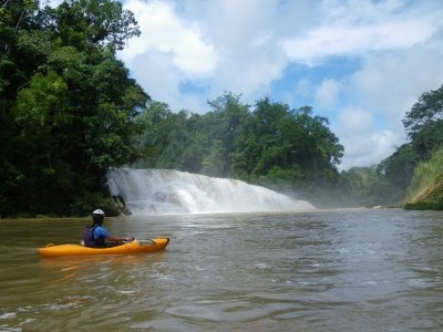
Class: III; Ave. Gradient: 2 m/km; Portages: 0 or 1 (IV); Length: 14.5 km; Time: 2:30

Season: year-round; rafts? yes; Highlights: view of Agua Azul waterfalls; Crux Move: one big rapid

Water Quality: decent; Water Temperature: medium

PI: unnamed bridge (elev.: 97m); TO: Agua Clara

Description: (click here for general notes about my descriptions)

The trip on the Río Shumuljá is a classic tourist float past the otherwise-hidden base of the Agua Azul waterfalls. There are not too many rapids along the way, though one in particular must be paid attention to.

From the PI beneath the bridge, it's 20 to 40 minutes of flat water down to the base of the falls; i.e., the confluence with the Río Agua Azul. This impressive sight (and noise) is worth the trip in itself for those not ready to descend the falls themselves. The base of the falls is 100m wide, and you will pass through some squirrely currents on your way past but nothing too treacherous. The more foolhardy in your group may try climbing up on the upstream edge and work their way out on the falls to find a place to jump off.

500 m below the falls, around the corner, is the crux rapid. It's actually 2 back-to-back rapids whose difficulty is very flow-dependent, and you will want to scout. At certain flows the 2nd rapid is considered a class V by rafters, who often portage it. For kayakers the difficulty varies between III and IV. My wife can confirm that the holes can get quite powerful.

In the final half of the run there are less than a handful of rapids, all in the II to III range. Class II boaters can manage this river if they are willing to portage the crux over the awkward rocks and have a good leader along.

The TO is a pretty picnic area (Balneario El Salvador) on river-right just past a boat ferry. (Note that you will be asked to pay a park fee to take-out here unless you take the public access trail right at the boat ferry.)

Flash Flood Danger: normal.

Descent History: The first descents I have heard about were in the 80's and had Scott Davis along. He also led the group that navigated the Chich upstream and explored the Yochibha & Chen caves which connects the Chich and the Shumuljá in spectacular fashion.

Flow Notes: There is a streamflow gage downstream on the Río Tulijá, linked to below. I would guess that the Shumuljá at the TO has 1/2 to 2/3 of the gage's flow. My impressions are with 2000 to 4000+ cfs at the TO. Below I also show historical flows at the Tulijá gage.

cfs graph cfs graph


Shuttle Notes: To get the PI, find the turn 1.2 km south of the Xanil bridge (upper Agua Azul) on the Palenque-Ocosingo highway (No. 199) and take that road about 16 km until it crosses over the river. The TO is at the Balneario El Salvador (river-side picnic area) in Agua Clara. To get there, get back on the Palenque highway and go about 17 km towards Palenque, where you will find a signed left turn at km 76.1 onto the 1.5 km-long road into Agua Clara (note that the communities may charge a negociable toll on this road). When you arrive at the Balneario, park outside the gate and walk down the public access path to the boat ferry (alternatively, drive into the park and wait there, there is a small entrance fee charged each person though).

Those without a car will find public transport to/from the river hard to come by.

Accommodations: Palenque town is the area's main tourist center, with many hotels and campgrounds. There are also cabañas at Agua Azul.

Nearby Tourist Attractions: This area has many natural and cultural tourist attractions, including the Falls upstream on the Agua Azul, the nearby Misol-Há waterfall, and the Mayan ruins at Palenque.

mayanwhitewater.com, the guide to the rivers of Chiapas, Guatemala, Belize, Honduras, and El Salvador © 2012