 rivers | guidebooks | forums | tips | other
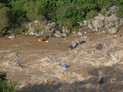
(photo by Roberto Rodas)
Class: IV+; Ave. Gradient: 8 m/km; Portages: 0-3; Length: up to 53 km; Time: up to 8:00
Season: June to November; rafts? a challenge; Highlights: big waves; Crux move: Lu-Lu rapid
Water Quality: poor; Water Temperature: medium
PI: San Gaspar Ixchil (1395 m) or San Miguel (1253 m) or Cuilco (1145 m); TO: roadside down to Canibal (980 m)
Description: (click here for general notes about my descriptions)
The Río Cuilco is born near Central America’s peak, Tajumulco volcano, and subsequently circles and drains the entire north side of the massif. The river gives paddlers the longest stretch of feasible whitewater in Central America, over 130 km in Guatemala alone, plus another 33+ km in Mexico. The Lower section contains the best and most reliable whitewater action, and is set in a Himalayan-scale valley. The area is also interesting culturally, with traditional lifestyles still apparent in the indigenous villages. Along the way is one section that is notably harder than the rest of the river.
A full description is in the Mayan Whitewater Guatemala guidebook.
Descent History: First descent of the lower-lower (from Cuilco II) was on 05.11.03 by Greg Schwendinger. First descent of middle-lower (from San Miguel) was by Roberto Rodas, Gary Chrisman, and Greg Schwendinger on 10.10.04 (it was attempted by rafters years earlier but they bailed at Lu-Lu and hiked back up). First descent of the upper-lower (from San Gaspar Ixchil) was on 01.09.10 by Greg Schwendinger.
Flow Notes: The most useful gauge is way downstream at San Miguel, Mexico (below the confluence with the Río Independencia), linked to below. In 2010, 17,000 cfs on this gauge gave about 4,000 cfs at San Gaspar Ixchil (the highest I've seen it). During the rainy season you can be sure of a boatable flow in the lower bits, but in low-water years it may be bony at San Gaspar Ixchil. If the Selegua (alongside the border-to-Huehuetenango road) has runnable water, the Cuilco probably does also. The Cuilco is a bigger river than the Selegua, but also wider/shallower, and its season is a bit shorter.
 |
Nearby Tourist Attractions: the roads are scenic, and you can also search out the primitive hot springs in the area.
mayanwhitewater.com, the guide to the rivers of Chiapas, Guatemala, Belize, Honduras, El Salvador, and Nicaragua © 2008-2023
![]()