 rivers | guidebooks | forums | tips | other
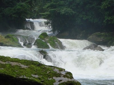
Class: III to IV; Ave. Gradient: 7 m/km; Portages: 5 to 10, some long; Length: up to 60 km ; Time: up to 4 days
Season: mid-June to February; rafts? middle part; Highlights: scenery, scary-looking rapids; Crux move: portaging on slippery rocks and shuttle coordination
Water Quality: good; Water Temperature: cool
PI: La Pimienta Bridge (elev: 1122m), or lower; TO: Amparo Agua Tinta, or higher
Description: (click here for general notes about my descriptions)
The Río Santo Domingo enjoys legendary status as the keeper of remote impassable canyons and unbelievably turquoise water. Many kayakers have seen the jaw-dropping waterfalls of the lower canyons on videos, but few have actually ventured close enough to see what it's all about. The falls in the upper section are not as high as in Canyon #5a, but they are spectacular nonetheless. The run-to-portage ratio is low, but it's better than in the lower section, and in my opinion it's worth doing once if you enjoy a lot of limestone-sprouted scenery with your emerald-green river and long portages on slippery rocks don't put you off.
A full description is in the Mayan Whitewater: Chiapas & Belize guidebook.
*note* This run is marked politically sensitive since there are many Zapatista communities in the area that limit access to their lands for outsiders. I have not had any problems at the points mentioned above, but I have been asked to leave other areas when I was poking around looking for alternative access above canyon #1 on river-left.
Flow Notes: There is a "Lacantún" streamflow gauge way downstream, linked to below; I have not verified its accuracy. The volume in the upper section of the Santo Domingo is a fractional part, less than 10%. Being largely spring-fed, it has an extended season but can get quite low from March to the beginning of June. In 2011, 15,000 cfs gave about 500 cfs in canyon #2 (a fairly ideal flow for the big stuff). Below I show historical flows near the top and bottom of the run. During the height of the rainy season (September-October) it would be prudent to check the flows down below before putting-on up top. My impressions of #1 & #2 are from a trip in late August 2009 with about 1500 cfs at #2, and my impressions of #3 & #4 are from a December 2004 trip with about 1200 cfs.
Another hint to flows can be garnered via the rain gauges, also shown below. The Comitán gauge is close to the Santo Domingo headwaters, while the Ocosingo gauge is close to the Jataté headwaters, the other main source of water for the Lacantún gauge.
 |
 |
 |
 |
 |
 |
Accommodations: On the northern end, there are no hotels east of Las Margaritas. On the southern end, you can ask around for a bed in Río Blanco otherwise you need to get out to the border highway to find the basic hotels at Pacayal/Nuevo San Juan Chamula.
Nearby Tourist Attractions: the stunning Lagunas de Montebello that are on the way out to Comitán.
mayanwhitewater.com, the guide to the rivers of Chiapas, Guatemala, Belize, Honduras, El Salvador, and Nicaragua © 2008-2024
![]()